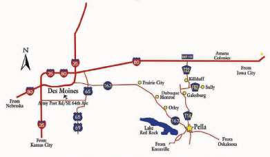
Maps to Campus & Pella
Driving directions
From the north:
Take exit 173, Kellogg/Sully off I-80. Drive south on T-14 (which turns into Main Street), follow the signs to Pella. At Pella, T-14 turns into Main Street, continue south until you reach the stoplight at University Street. Turn right and go one and a half blocks to Central College. The parking lot for the office of admission will be located on the right side of the street.
From the east:
From Highway 102, drive until you reach the stop sign at Hazel Street. Turn left and follow the curve to the stoplight at Main Street, turn left and drive to University Street, then follow directions above.
From the southeast:
From Highway 163 take exit 42, turn right and head north and drive to Oskaloosa Street. Turn left and follow the road to the stoplight at University Street. Turn left and follow directions above.
From the southwest:
Take T-15 across the dam over Lake Red Rock. Take the first road right after crossing the dam. Central College will be on your left after about 3 1/2 miles.
From the west:
Take Highway 163 to exit 40, turn left. Drive to the stoplight at the corner of Pella’s town square and turn right onto Broadway Street. Drive to University Street and turn right, the parking lot for the office of admission will be located on the right side of the street about halfway down the block.
More maps:
Maps courtesy of the Pella Convention & Visitors Bureau

